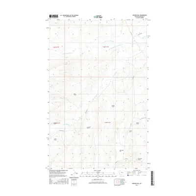
2017 Map of Hoodoo Hill
USGS Topo · Published 2017About this map
The Middle Fork Milk River and the S Fork Milk River carve through this landscape in Glacier County, Montana, showing a complex drainage network of coulees and shifting channels. The presence of the Old Channel Middle Fork Milk River indicates the natural movement of these waterways over time across the northern plains. This 2017 survey highlights a terrain defined by significant landforms like Hoodoo Hill and Houseman Hill, along with numerous named drainages such as Peterson Coulee and Sand Rock Coulee. Transportation in this rural area is marked by a network of local routes including Burd Ranch Rd, Buck Ranch Rd, and Spotting Elk Rd, reflecting the ranching and tribal land use patterns of the modern era. The southern portion of the map is traversed by the Arnoux Trl, providing a look at the remote access routes near Nightshoot Coulee.
Find a feature on this map
23 named features on this map. Tap any name to fly to it.
Don’t see what you’re looking for? This feature index may not catch every label — zoom into the map to look around manually.
Map Details
Editions of this 2017 Hoodoo Hill Map
This is the sole edition of this map. No revisions or reprints were ever made.
Other maps of this area

1901 · Browning
USGS Topo · 1:125,000

1903 · Browning
USGS Topo · 1:125,000

1911 · Blackfoot
USGS Topo · 1:125,000

1960 · Cut Bank
USGS Topo · 1:250,000

1963 · Cut Bank
USGS Topo · 1:250,000

1964 · Cut Bank
USGS Topo · 1:250,000

1968 · Hoodoo Hill
USGS Topo · 1:24,000

1968 · Browning NE
USGS Topo · 1:24,000
1968 · Emigrant Gap
USGS Topo · 1:24,000
1968 · Hall Coulee
USGS Topo · 1:24,000