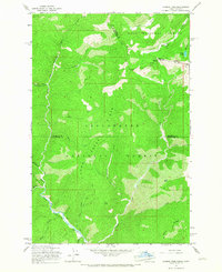
1965 Map of Hoodoo Pass
USGS Topo · Published 1967About this map
The high Bitterroot Divide along the Montana-Idaho border is the central focus of this 1965 survey. At the crest sits Hoodoo Pass, a high-altitude crossing point where the Hoodoo Pack Trail transitions between the Lolo National Forest to the northeast and the Clearwater National Forest to the southwest. The rugged geography is defined by steep drainages feeding the North Fork Clearwater River, which winds through the southwestern corner of the sheet. Notable high points like Trap Point and Short Point overlook deep canyons carved by Rawhide Creek and Long Creek. Evidence of early communication infrastructure is found near the pass at the Radio Tower, while the name Vanderbilt Gulch suggests the influence of early mining or timber prospecting in this isolated mountain landscape.
Find a feature on this map
32 named features on this map. Tap any name to fly to it.
Don’t see what you’re looking for? This feature index may not catch every label — zoom into the map to look around manually.
Map Details
Editions of this 1965 Hoodoo Pass Map
Other maps of this area

1911 · Lolo
USGS Topo · 1:250,000

1913 · Lolo
USGS Topo · 1:250,000

1918 · St Regis
USGS Topo · 1:125,000

1919 · St. Regis
USGS Topo · 1:125,000

1956 · Wallace
USGS Topo · 1:250,000

1956 · Hamilton
USGS Topo · 1:250,000

1957 · Illinois Peak
USGS Topo · 1:62,500

1959 · Hamilton
USGS Topo · 1:250,000

1960 · Wallace
USGS Topo · 1:250,000

1960 · Hamilton
USGS Topo · 1:250,000