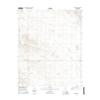
2014 Map of Hoodoo Well
USGS Topo · Published 2014About this map
Hoodoo Well serves as a lone point of interest in this arid expanse of Yuma County, marking a vital water source for desert travel. The landscape is defined by the sweeping Palomas Plain and a network of seasonal drainages including Red Raven Wash, Moonshine Gulch, and the prominent Hoodoo Wash. These drainage patterns indicate the flash-flood character of the local geography, where water only briefly shapes the sandy floor. Transportation across this territory is facilitated by a handful of established desert routes, most notably the Kofa Manganese Rd, which suggests the area's history of mineral exploration and extraction. To the east, Engesser Pass Rd and Alamo Rd cross the terrain, providing access through the basin-and-range topography typical of the southwest Arizona desert.
Find a feature on this map
13 named features on this map. Tap any name to fly to it.
Don’t see what you’re looking for? This feature index may not catch every label — zoom into the map to look around manually.
Map Details
Editions of this 2014 Hoodoo Well Map
This is the sole edition of this map. No revisions or reprints were ever made.
Other maps of this area

1942 · Vicksburg
USGS Topo · 1:250,000

1954 · Phoenix
USGS Topo · 1:250,000

1957 · Phoenix
USGS Topo · 1:250,000

1958 · Phoenix
USGS Topo · 1:250,000

1960 · Phoenix
USGS Topo · 1:250,000

1962 · Little Horn Mts
USGS Topo · 1:62,500

1962 · Kofa Butte
USGS Topo · 1:62,500
1965 · Engesser Pass
USGS Topo · 1:62,500
1965 · Palomas Mts
USGS Topo · 1:62,500

1969 · Phoenix
USGS Topo · 1:250,000