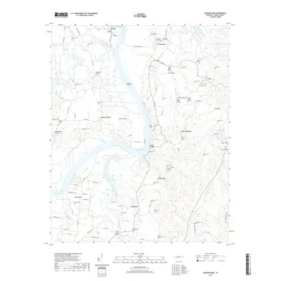
2019 Map of Hookers Bend
USGS Topo · Published 2019About this map
Saltillo and Cerro Gordo anchor the banks of the Tennessee River as it winds through Hardin County, forming the prominent geography of Hookers Bend. This 2019 survey captures a landscape defined by its river-bend settlements and an extensive network of family cemeteries, such as Boiling Springs Cem and Tarbet Cem. The hydrology is complex, featuring Kentucky Lake and numerous tributaries like Indian Creek and Horse Creek, while landmarks like Petticoat Riffles and Mary Jane Bluff speak to the river's navigational and geological history. Genealogists will find significant value in the dense clustering of rural burial sites, including Old Russell Chapel Cem and New Russell Chapel Cem near Stringtown. Transportation routes bridge the many waterways, evidenced by the White Oak Bridge and Paulsks Mill Bridge, illustrating how the community remains interconnected despite the shifting terrain of bluffs and bottoms.
Find a feature on this map
117 named features on this map. Tap any name to fly to it.
Don’t see what you’re looking for? This feature index may not catch every label — zoom into the map to look around manually.
Map Details
Editions of this 2019 Hookers Bend Map
This is the sole edition of this map. No revisions or reprints were ever made.
Other maps of this area

1936 · Savannah
USGS Topo · 1:24,000

1936 · Wolf Pit Ridge
USGS Topo · 1:24,000

1936 · Hookers Bend
USGS Topo · 1:24,000

1936 · Thurman
USGS Topo · 1:24,000

1936 · Olivehill
USGS Topo · 1:24,000

1936 · Bath Springs
USGS Topo · 1:24,000

1936 · Sardis
USGS Topo · 1:24,000

1936 · Milledgeville
USGS Topo · 1:24,000

1936 · Pittsburg Landing
USGS Topo · 1:24,000

1949 · Hookers Bend
USGS Topo · 1:24,000