
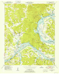
1936 Map of Hookers Bend
USGS Topo · Published 1936About this map
Tennessee River traffic and landing points define this reach of Hardin County, surveyed just as the Tennessee Valley Authority began its transformative work in the region. The river is the central artery, punctuated by several historic access points including Cravens Landing, Dickey Landing, and the Saltillo Ferry at the northern edge. Inland from the river's distinctive loops at Pitts Bend and Hookers Bend, a network of small agricultural communities like Cerro Gordo, Swift, and New Harmony are visible, each anchored by local institutions. Genealogists will find many family-named landmarks and rural burial grounds, such as Smith Cem and Mc Casland Cem, alongside numerous country schools including Antioch Sch and Berlin Sch. The landscape is a complex web of small drainages like Indian Creek and Horse Creek, which necessitated early infrastructure such as the White Oak Bridge and Paulks Mill Bridge.
Find a feature on this map
85 named features on this map. Tap any name to fly to it.
Don’t see what you’re looking for? This feature index may not catch every label — zoom into the map to look around manually.
Map Details
Editions of this 1936 Hookers Bend Map
This is the sole edition of this map. No revisions or reprints were ever made.
Other maps of this area

1936 · Savannah
USGS Topo · 1:24,000

1936 · Wolf Pit Ridge
USGS Topo · 1:24,000

1936 · Thurman
USGS Topo · 1:24,000

1936 · Olivehill
USGS Topo · 1:24,000

1936 · Bath Springs
USGS Topo · 1:24,000

1936 · Sardis
USGS Topo · 1:24,000

1936 · Milledgeville
USGS Topo · 1:24,000

1936 · Pittsburg Landing
USGS Topo · 1:24,000

1949 · Hookers Bend
USGS Topo · 1:24,000
1949 · Bath Springs
USGS Topo · 1:24,000