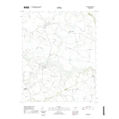
2019 Map of Hookerton
USGS Topo · Published 2019About this map
Hookerton and its surrounding rural landscapes are defined by the meandering course of Contentnea Creek, which serves as a central waterway for this portion of eastern North Carolina. The settlement patterns are characterized by small crossroads communities and scattered farming operations, with places like Maury, Ormondsville, and Hugo linked by a network of local roads bearing prominent family names. These roads, such as Beddard Farm Rd and Frizzelle Farm Rd, reflect the agricultural lineage of Greene County. To the north, the terrain transitions into the distinct wetland environments of Rices Pocosin and Half Moon Pocosin, while Wheat Swamp and Eagle Swamp dominate the southern reaches near the Lenoir County line. Local history is anchored by landmarks such as Rainbow Cem and the small aviation footprint of Chase Field just northwest of the town center.
Find a feature on this map
82 named features on this map. Tap any name to fly to it.
Don’t see what you’re looking for? This feature index may not catch every label — zoom into the map to look around manually.
Map Details
Editions of this 2019 Hookerton Map
This is the sole edition of this map. No revisions or reprints were ever made.
Other maps of this area

1902 · Ayden
USGS Topo · 1:62,500

1903 · Winterville
USGS Topo · 1:62,500

1904 · Ayden
USGS Topo · 1:62,500

1904 · Falkland
USGS Topo · 1:62,500

1905 · Winterville
USGS Topo · 1:62,500

1914 · Kinston
USGS Topo · 1:48,000

1916 · Kinston
USGS Topo · 1:62,500

1953 · Rocky Mount
USGS Topo · 1:250,000

1954 · Rocky Mount
USGS Topo · 1:250,000
1981 · Farmville
USGS Topo · 1:24,000