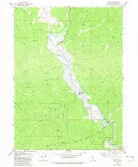
1979 Map of Hoopa
USGS Topo · Published 1983About this map
The Trinity River defines the heart of this region, winding through the Hoopa Valley in a landscape marked by steep ridges and tribal heritage. This late 1970s survey captures the community of Hoopa during a period of infrastructure development, shown by the presence of the Hoopa Valley Landing Strip and a nearby Substa. The map provides significant cultural context with the identification of The Rain Rock (Indian Ceremonial Site) near the river's bend, while the Hoopa Valley Indian Reservation Boundary and Six Rivers National Forest delineate the complex land management of the area.
Find a feature on this map
53 named features on this map. Tap any name to fly to it.
Don’t see what you’re looking for? This feature index may not catch every label — zoom into the map to look around manually.
Map Details
Editions of this 1979 Hoopa Map
2 editions found
Other maps of this area

1915 · Big Bar and Vicinity
USGS Topo · 1:250,000

1922 · Korbel
USGS Topo · 1:62,500

1922 · China Flat
USGS Topo · 1:62,500

1925 · Hoopa
USGS Topo · 1:125,000

1945 · Coyote Peak
USGS Topo · 1:62,500

1945 · Blue Lake
USGS Topo · 1:62,500

1948 · Weed
USGS Topo · 1:250,000

1950 · Weed
USGS Topo · 1:250,000

1951 · Blue Lake
USGS Topo · 1:62,500

1952 · Willow Creek
USGS Topo · 1:62,500