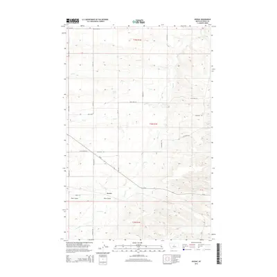
2014 Map of Hoosac
USGS Topo · Published 2014About this map
Hoosac sits at the southern edge of this Montana landscape, where the flatlands of Pacer Coulee meet a network of high ridges and drainage basins. This area of Fergus County is defined by its hydraulic patterns, with Smith Cr, Ox Cr, and Wolf Cr carving out deep relief across the township blocks of T19N, T18N, and T17N. The map reveals a specialized rural infrastructure, notably the Colton Airport Rd and a series of family-named thoroughfares like Barker Rd and Hitchcock Rd that navigate the varied elevations. Landmarks such as Bally Dome and Osborn Spring serve as critical points of reference in a terrain where water sources and topographic high points dictate the layout of the land and its access routes.
Find a feature on this map
26 named features on this map. Tap any name to fly to it.
Don’t see what you’re looking for? This feature index may not catch every label — zoom into the map to look around manually.
Map Details
Editions of this 2014 Hoosac Map
This is the sole edition of this map. No revisions or reprints were ever made.
Other maps of this area

1954 · Lewistown
USGS Topo · 1:250,000

1959 · Lewistown
USGS Topo · 1:250,000

1970 · Harwood Bench
USGS Topo · 1:24,000

1970 · Danvers
USGS Topo · 1:24,000
1970 · Big Spring
USGS Topo · 1:24,000
1978 · Soda Spring Coulee
USGS Topo · 1:24,000

1978 · Wild Bill Flat West
USGS Topo · 1:24,000

1978 · Toney Bench
USGS Topo · 1:24,000
1978 · Hoosac
USGS Topo · 1:24,000

1978 · Lewistown
USGS Topo · 1:100,000