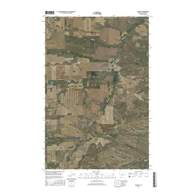
2017 Map of Hoosac
USGS Topo · Published 2017About this map
Hoosac sits at the heart of this Fergus County landscape, where the high plains are carved by a network of drainage systems flowing through the Montana rangeland. The terrain is defined by the deep incision of Pacer Coulee and the winding paths of Dry Wolf Cr and Smith Cr. This 2017 survey reveals a remote section of the state where a grid of long-established ranch roads—such as Bally Dome Rd, Donaldson Rd, and Goettmoeller Rd—provides the primary structure for movement between isolated homesteads. Landmarks like Osborn Spring and various creeks including Ox Cr and Sage Cr indicate the vital importance of water sources in this dry environment. The presence of the Colton Airport Rd suggests a local reliance on small-scale aviation for connectivity in this sparsely populated region of central Montana.
Find a feature on this map
23 named features on this map. Tap any name to fly to it.
Don’t see what you’re looking for? This feature index may not catch every label — zoom into the map to look around manually.
Map Details
Editions of this 2017 Hoosac Map
This is the sole edition of this map. No revisions or reprints were ever made.
Other maps of this area

1954 · Lewistown
USGS Topo · 1:250,000

1959 · Lewistown
USGS Topo · 1:250,000

1970 · Harwood Bench
USGS Topo · 1:24,000

1970 · Danvers
USGS Topo · 1:24,000
1970 · Big Spring
USGS Topo · 1:24,000
1978 · Soda Spring Coulee
USGS Topo · 1:24,000

1978 · Wild Bill Flat West
USGS Topo · 1:24,000

1978 · Toney Bench
USGS Topo · 1:24,000
1978 · Hoosac
USGS Topo · 1:24,000

1978 · Lewistown
USGS Topo · 1:100,000