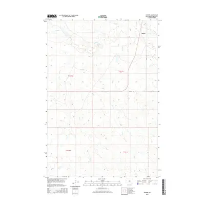
2015 Map of Hoover
USGS Topo · Published 2015About this map
Hoover is situated in a landscape defined by the drainage of the S Fork Moreau River in western South Dakota. This 2015 survey reveals a terrain carved by numerous tributaries, including Bull Cr, Frog Cr, and Hans Cr, which thread through the plains. The settlement of Hoover serves as a small hub where Hoover Rd and Graf Rd intersect, marking a junction of rural transit in Butte County.
Find a feature on this map
14 named features on this map. Tap any name to fly to it.
Don’t see what you’re looking for? This feature index may not catch every label — zoom into the map to look around manually.
Map Details
Editions of this 2015 Hoover Map
This is the sole edition of this map. No revisions or reprints were ever made.
Other maps of this area

1913 · Newell
USGS Topo · 1:125,000

1935 · Hoover
USGS Topo · 1:125,000

1953 · Rapid City
USGS Topo · 1:250,000

1954 · Lemmon
USGS Topo · 1:250,000

1957 · Lemmon
USGS Topo · 1:250,000

1957 · Rapid City
USGS Topo · 1:250,000

1973 · Lone Tree Draw East
USGS Topo · 1:24,000
1973 · Deers Ears Butte North
USGS Topo · 1:24,000
1973 · Haystack Butte
USGS Topo · 1:24,000
1977 · Hoover
USGS Topo · 1:24,000