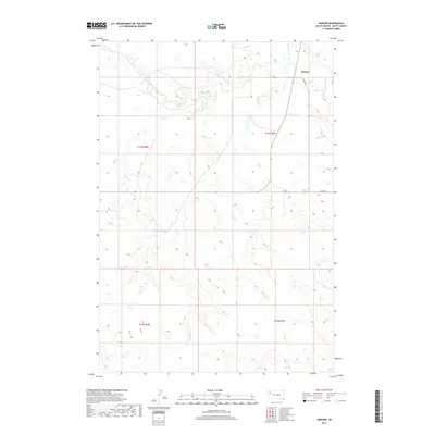
2017 Map of Hoover
USGS Topo · Published 2017About this map
Hoover serves as the primary landmark in this corner of Butte County, situated in a landscape defined by the drainage network of the S Fork Moreau River. The terrain is marked by numerous ephemeral watercourses, including Sand Creek, Badlands Creek, and Bull Creek, which shape the local topography. This 2017 survey shows the sparse infrastructure of the region, where gravel and dirt roads like Hoover Rd and Erk Rd provide the only access across the vast sections of land. The township and range lines of t13n r7e and t12n r6e illustrate the continued importance of the Public Land Survey System in organizing this rural territory. Historically-minded researchers can trace the movement of water and livestock through basins fed by Frog Creek and Hans Creek in a region where natural features often dictate the placement of human improvements.
Find a feature on this map
14 named features on this map. Tap any name to fly to it.
Don’t see what you’re looking for? This feature index may not catch every label — zoom into the map to look around manually.
Map Details
Editions of this 2017 Hoover Map
This is the sole edition of this map. No revisions or reprints were ever made.
Other maps of this area

1913 · Newell
USGS Topo · 1:125,000

1935 · Hoover
USGS Topo · 1:125,000

1953 · Rapid City
USGS Topo · 1:250,000

1954 · Lemmon
USGS Topo · 1:250,000

1957 · Lemmon
USGS Topo · 1:250,000

1957 · Rapid City
USGS Topo · 1:250,000

1973 · Lone Tree Draw East
USGS Topo · 1:24,000
1973 · Deers Ears Butte North
USGS Topo · 1:24,000
1973 · Haystack Butte
USGS Topo · 1:24,000
1977 · Hoover
USGS Topo · 1:24,000