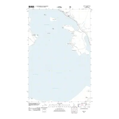
2011 Map of Hope
USGS Topo · Published 2011About this map
Lake Pend Oreille dominates this northern Idaho landscape, surrounding a collection of named landforms including Memaloose Island, Warren Island, and Pearl Island. The neighboring lakeside communities of Hope and East Hope are established along the northeastern shoreline, where Strong Creek meets the water. This 2011 survey captures the area's mix of recreational and historical importance, evidenced by the Lake Pend Oreille Seaplane Base near Picard Point and the Samowen Campground on the peninsula.
Find a feature on this map
30 named features on this map. Tap any name to fly to it.
Don’t see what you’re looking for? This feature index may not catch every label — zoom into the map to look around manually.
Map Details
Editions of this 2011 Hope Map
This is the sole edition of this map. No revisions or reprints were ever made.
Other maps of this area

1911 · Priest Lake
USGS Topo · 1:250,000

1913 · Priest Lake
USGS Topo · 1:250,000

1949 · Packsaddle Mtn
USGS Topo · 1:62,500

1951 · Packsaddle Mtn
USGS Topo · 1:62,500

1951 · Clark Fork
USGS Topo · 1:62,500

1951 · Mt Pend Oreille
USGS Topo · 1:62,500

1951 · Elmira
USGS Topo · 1:62,500

1958 · Sandpoint
USGS Topo · 1:250,000

1963 · Sandpoint
USGS Topo · 1:250,000
1984 · Sandpoint
USGS Topo · 1:100,000