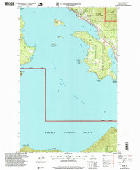
1996 Map of Hope
USGS Topo · Published 1999About this map
Lake Pend Oreille dominates the landscape of this Idaho Panhandle survey, where the settlements of Hope and East Hope cling to the northern shoreline beneath the slopes of the Kaniksu National Forest. The map captures a complex shoreline of points and bays, from Anderson Point in the northwest to Sheepherder Point in the south, punctuated by significant islands like Warren Island and the smaller Cottage Island. A local Lighthouse on Pearl Island and a Marina in Ellisport Bay reflect the maritime character of the community in the late 1990s. The southern reaches of the quadrangle reveal an industrial and conservationist layer, featuring the Green Monarch Mine near Deadman Point and the protected lands of the David Thompson State Wildlife Preserve, showcasing the region's balance between resource extraction and environmental stewardship.
Find a feature on this map
38 named features on this map. Tap any name to fly to it.
Don’t see what you’re looking for? This feature index may not catch every label — zoom into the map to look around manually.
Map Details
Editions of this 1996 Hope Map
This is the sole edition of this map. No revisions or reprints were ever made.
Other maps of this area

1911 · Priest Lake
USGS Topo · 1:250,000

1913 · Priest Lake
USGS Topo · 1:250,000

1949 · Packsaddle Mtn
USGS Topo · 1:62,500

1951 · Packsaddle Mtn
USGS Topo · 1:62,500

1951 · Clark Fork
USGS Topo · 1:62,500

1951 · Mt Pend Oreille
USGS Topo · 1:62,500

1951 · Elmira
USGS Topo · 1:62,500

1958 · Sandpoint
USGS Topo · 1:250,000

1963 · Sandpoint
USGS Topo · 1:250,000
1984 · Sandpoint
USGS Topo · 1:100,000