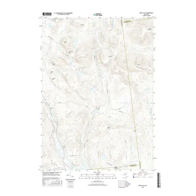
2016 Map of Hope Falls
USGS Topo · Published 2016About this map
East Stony Creek and its many tributaries, such as Tenant Cr and Bear Cr, define the drainage patterns of this high-relief landscape within the Adirondack Park Preserve. Small, isolated settlements like Hope Falls and Maple Grove are situated along narrow valley floors, connected by a network of rural roads including Hope Falls Rd and Creek Rd. For those researching local family history, the Wadsworth Cem and Willard Cem are clearly marked near the Sacandaga River. High peaks such as Huckleberry Mtn, Sturgis Mtn, and Gene Edwards Mtn surround numerous high-altitude water bodies, including Murphy Lake and Bennett Lake, illustrating the topographical complexity of the Hamilton, Fulton, and Saratoga county borders.
Find a feature on this map
60 named features on this map. Tap any name to fly to it.
Don’t see what you’re looking for? This feature index may not catch every label — zoom into the map to look around manually.
Map Details
Editions of this 2016 Hope Falls Map
This is the sole edition of this map. No revisions or reprints were ever made.
Other maps of this area

1899 · Broadalbin
USGS Topo · 1:62,500

1902 · Broadalbin
USGS Topo · 1:62,500

1903 · Gloversville
USGS Topo · 1:62,500

1907 · Lake Pleasant
USGS Topo · 1:62,500

1910 · Stony Creek
USGS Topo · 1:62,500

1943 · Gloversville
USGS Topo · 1:62,500

1945 · Edinburg
USGS Topo · 1:24,000

1945 · Northville
USGS Topo · 1:24,000
1945 · Jackson Summit
USGS Topo · 1:24,000
1946 · Edinburg
USGS Topo · 1:24,000