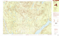
1999 Map of Hope Falls
USGS Topo · Published 2000About this map
The Adirondack Park and its State Forest Preserve dominate this 1990s terrain, revealing the quiet interface between protected wilderness and small riverside communities. Along the southeastern edge, the waters of Great Sacandaga Lake border the settlements of Day Center and West Day, while the Sacandaga River flows through the western reaches. This survey shows a landscape defined by prominent peaks like Rice Mountain and Youngs Mountain, separated by a network of drainage basins including Stony Creek and East Stony Creek. Small pockets of habitation like Hope Falls and Maple Grove are connected by forest roads, providing a view of the region's late-century rural character and the enduring boundaries between Hamilton, Saratoga, and Fulton counties.
Find a feature on this map
69 named features on this map. Tap any name to fly to it.
Don’t see what you’re looking for? This feature index may not catch every label — zoom into the map to look around manually.
Map Details
Editions of this 1999 Hope Falls Map
This is the sole edition of this map. No revisions or reprints were ever made.
Other maps of this area

1899 · Broadalbin
USGS Topo · 1:62,500

1902 · Broadalbin
USGS Topo · 1:62,500

1902 · Saratoga
USGS Topo · 1:62,500

1903 · Luzerne
USGS Topo · 1:62,500

1903 · Gloversville
USGS Topo · 1:62,500

1907 · Lake Pleasant
USGS Topo · 1:62,500

1910 · Stony Creek
USGS Topo · 1:62,500

1942 · Saratoga
USGS Topo · 1:62,500

1943 · Gloversville
USGS Topo · 1:62,500

1945 · Edinburg
USGS Topo · 1:24,000