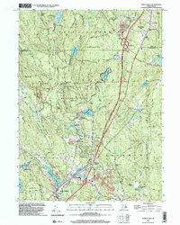
2001 Map of Hope Valley
USGS Topo · Published 2003About this map
The Wood River drainage defines the landscape of western Rhode Island at the turn of the 21st century, flowing through a series of mill-era ponds and small villages. Settlements like Hope Valley and Wyoming anchor the southern portion of the map, where Locustville Pond and Canob Pond reflect the industrial water-power origins of these communities. To the north, the terrain transitions into the protected woodlands of the Arcadia State Management Area and Big River State Management Area, preserving a rural character punctuated by landmarks like Bald Hill and Breakheart Hill. The map traces the historical fabric of the region through numerous family burial sites, including Lillibridge Cem and Barber Cem, while showing the modern influence of Interstate 95 as it cuts through Black Plain. Functional sites like the Fish Hatchery near Browning Mill Pond demonstrate the long-standing management of the area's aquatic resources.
Find a feature on this map
74 named features on this map. Tap any name to fly to it.
Don’t see what you’re looking for? This feature index may not catch every label — zoom into the map to look around manually.
Map Details
Editions of this 2001 Hope Valley Map
This is the sole edition of this map. No revisions or reprints were ever made.
Other maps of this area

1889 · Stonington
USGS Topo · 1:62,500

1889 · Charlestown
USGS Topo · 1:62,500

1889 · Moosup
USGS Topo · 1:62,500

1890 · Kent
USGS Topo · 1:62,500

1893 · Moosup
USGS Topo · 1:62,500

1893 · Stonington
USGS Topo · 1:62,500

1894 · Kent
USGS Topo · 1:62,500

1919 · Charlestown
USGS Topo · 1:62,500

1920 · Moosup
USGS Topo · 1:62,500

1921 · Charlestown
USGS Topo · 1:62,500