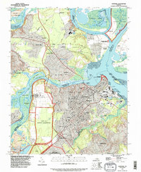
1994 Map of Hopewell
USGS Topo · Published 1996About this map
The Hopewell industrial waterfront and the sprawling Fort Lee Military Reservation anchor this mid-1990s geographic study of the confluence of the James River and Appomattox River. The landscape reflects a complex mix of heavy industry, represented by numerous industrial waste ponds and a large Federal Reformatory, alongside deep historical preservation at the Petersburg National Battlefield near City Point. Residential patterns in Highland Park, Kenwood, and Screamersville contrast with the large naturalized buffers of the Presquille National Wildlife Refuge.
Find a feature on this map
91 named features on this map. Tap any name to fly to it.
Don’t see what you’re looking for? This feature index may not catch every label — zoom into the map to look around manually.
Map Details
Editions of this 1994 Hopewell Map
This is the sole edition of this map. No revisions or reprints were ever made.
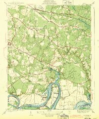
Other maps of this area

1894 · Bermuda Hundred
USGS Topo · 1:62,500

1894 · Petersburg
USGS Topo · 1:62,500

1918 · Charles City
USGS Topo · 1:62,500

1919 · Disputanta
USGS Topo · 1:62,500

1938 · Dutch Gap
USGS Topo · 1:24,000

1938 · Drewrys Bluff
USGS Topo · 1:24,000
1943 · Dutch Gap
USGS Topo · 1:31,680

1943 · Hopewell
USGS Topo · 1:31,680

1943 · Disputanta
USGS Topo · 1:31,680

1943 · Richmond
USGS Topo · 1:250,000