
1943 Map of Disputanta
USGS Topo · Published 1943About this map
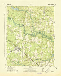
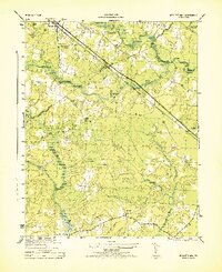
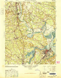
Garysville and Newville anchor the high ground in this wartime topographic study of the Prince George County interior. The landscape is defined by the expansive drainage networks of Blackwater Swamp and Otterdam Swamp, which feed into the Blackwater River. This 1943 survey, prepared under the direction of the Corps of Engineers, shows a rural community organized around crossroads and water-driven industry, including several Sawmill sites. Cultural landmarks like the National Moorish Home and the Old Academy School offer specific points of interest for local historians, while the distribution of numerous country churches, such as Sycamore Church and Bethlehem Church, illustrates the social geography of the era. The presence of Seldons Store and Binford Store near Lake Binford highlights the small-scale commercial hubs that once served the farmers and timber workers across this portion of the Virginia coastal plain.
Find a feature on this map
23 named features on this map. Tap any name to fly to it.
Don’t see what you’re looking for? This feature index may not catch every label — zoom into the map to look around manually.
Map Details
Editions of this 1943 Disputanta Map
This is the sole edition of this map. No revisions or reprints were ever made.
Other maps of this area

1894 · Bermuda Hundred
USGS Topo · 1:62,500

1894 · Petersburg
USGS Topo · 1:62,500

1918 · Charles City
USGS Topo · 1:62,500

1919 · Disputanta
USGS Topo · 1:62,500

1943 · Savedge
USGS Topo · 1:31,680

1943 · Hopewell
USGS Topo · 1:31,680

1943 · Richmond
USGS Topo · 1:250,000
1944 · Waverly
USGS Topo · 1:31,680
1944 · Nebletts Mill
USGS Topo · 1:31,680
1946 · Bermuda Hundred
USGS Topo · 1:62,500