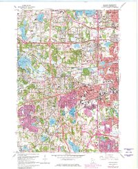
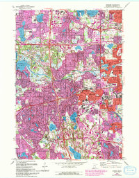
1967 Map of Hopkins
USGS Topo · Published 1981About this map
Hopkins and the western suburbs of Minneapolis appear in a period of intense post-war expansion, with the purple overprint revealing the rapid urban footprint growth between the mid-1950s and late 1970s. This survey details the complex intersection of the Chicago Milwaukee St Paul and Pacific and the Burlington Northern railroads as they weave through industrial zones like the Minneapolis Industrial Park. Significant institutional sites are meticulously noted, including the Workhouse near Medicine Lake and the large Glen Lake State Sanatorium complex. The landscape is defined by its water, from the eastern edge of Lake Minnetonka at Grays Bay to the course of Minnehaha Creek and Ninemile Creek. Local genealogy resources are abundant, including the Shady Oak Lake Cem, St Margaret Cem, and numerous parochial schools like St Patricks Sch.
Find a feature on this map
102 named features on this map. Tap any name to fly to it.
Don’t see what you’re looking for? This feature index may not catch every label — zoom into the map to look around manually.
Map Details
Editions of this 1967 Hopkins Map
5 editions found
Other maps of this area

1896 · Minneapolis
USGS Topo · 1:62,500

1901 · Minneapolis
USGS Topo · 1:62,500

1902 · Anoka
USGS Topo · 1:62,500

1905 · Minnetonka
USGS Topo · 1:62,500

1907 · Minnetonka
USGS Topo · 1:62,500

1909 · Rockford
USGS Topo · 1:62,500

1952 · Minneapolis North
USGS Topo · 1:24,000

1952 · Minneapolis South
USGS Topo · 1:24,000

1953 · Saint Paul
USGS Topo · 1:250,000

1953 · Stillwater
USGS Topo · 1:250,000