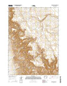
2014 Map of Hoppin Springs
USGS Topo · Published 2014About this map
W Little Owyhee River cuts through this high desert plateau, where water sources dictated the patterns of ranching and movement. The presence of numerous named water points, such as Hoppin Springs, Edge Spring, and Wild Rose Spring, indicates the vital importance of these locations for livestock in an arid environment. Human infrastructure is concentrated around the Larribeau Reservoir and the drainage of Nouque Ditch, supporting the pastoral activities of the region.
Find a feature on this map
28 named features on this map. Tap any name to fly to it.
Don’t see what you’re looking for? This feature index may not catch every label — zoom into the map to look around manually.
Map Details
Editions of this 2014 Hoppin Springs Map
This is the sole edition of this map. No revisions or reprints were ever made.
Other maps of this area

1882 · Paradise
USGS Topo · 1:250,000

1893 · Paradise
USGS Topo · 1:250,000

1955 · McDermitt
USGS Topo · 1:250,000

1955 · Jordan Valley
USGS Topo · 1:250,000

1957 · Jordan Valley
USGS Topo · 1:250,000

1958 · Jordan Valley
USGS Topo · 1:250,000

1959 · McDermitt
USGS Topo · 1:250,000

1959 · McDermitt
USGS Topo · 1:62,500

1980 · Odell Mountain
USGS Topo · 1:24,000
1982 · Jackson Summit
USGS Topo · 1:24,000