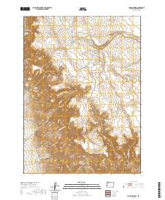
2020 Map of Hoppin Springs
USGS Topo · Published 2020About this map
Larribeau Reservoir and the headwaters of the W Little Owyhee River dominate this high-desert landscape in southeastern Oregon. This 2020 map documents a remote cattle-ranching and water-management network, where named drainage features like Nouque Ditch and Trail Cr are essential to the arid environment. A series of canyons, including Louse Canyon and Wood Canyon, provide topographical structure to the plateau, while the presence of named land parcels such as Juans Forty indicates the enduring legacy of private holdings within the public domain. Transportation in this quadrant is defined by utilitarian paths like Frenchman Creek Rd and Airplane Reservoir Rd, which connect isolated water sources like Hoppin Springs and Edge Spring. The density of named springs, including Andy Five Spring, suggests the critical importance of these reliable water points for livestock and wildlife across The Basin.
Find a feature on this map
29 named features on this map. Tap any name to fly to it.
Don’t see what you’re looking for? This feature index may not catch every label — zoom into the map to look around manually.
Map Details
Editions of this 2020 Hoppin Springs Map
This is the sole edition of this map. No revisions or reprints were ever made.
Other maps of this area

1882 · Paradise
USGS Topo · 1:250,000

1893 · Paradise
USGS Topo · 1:250,000

1955 · McDermitt
USGS Topo · 1:250,000

1955 · Jordan Valley
USGS Topo · 1:250,000

1957 · Jordan Valley
USGS Topo · 1:250,000

1958 · Jordan Valley
USGS Topo · 1:250,000

1959 · McDermitt
USGS Topo · 1:250,000

1959 · McDermitt
USGS Topo · 1:62,500

1980 · Odell Mountain
USGS Topo · 1:24,000
1982 · Jackson Summit
USGS Topo · 1:24,000