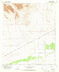
1965 Map of Horn
USGS Topo · Published 1966About this map
The Southern Pacific railroad corridor serves as the primary artery through this arid Yuma County landscape in the mid-1960s, connecting the settlement of Horn with the surrounding agricultural and industrial sites. In the San Cristobal Valley, evidence of desert commerce is visible through the presence of the Horn Cotton Gin and several nearby Storage Bins. To the north, the terrain rises into the Palomas Mountains, where the England Mine marks the area's mineral interests. The hydrologic character of the region is defined by the Gila River flowing through the southern portion of the quadrangle, while the Hoodoo Wash drains the central plains. Historical markers such as the Fort Horn Monument indicate the long-standing significance of this transit route, even as modern infrastructure like a Substation and a local Landing Strip supported twentieth-century development.
Find a feature on this map
16 named features on this map. Tap any name to fly to it.
Don’t see what you’re looking for? This feature index may not catch every label — zoom into the map to look around manually.
Map Details
Editions of this 1965 Horn Map
2 editions found
Other maps of this area

1927 · Hyder
USGS Topo · 1:62,500

1929 · Aztec
USGS Topo · 1:62,500

1930 · Stoval
USGS Topo · 1:62,500

1930 · Hyder
USGS Topo · 1:62,500

1942 · Vicksburg
USGS Topo · 1:250,000

1950 · Stoval
USGS Topo · 1:62,500

1950 · Aztec
USGS Topo · 1:62,500

1953 · Ajo
USGS Topo · 1:250,000

1954 · Phoenix
USGS Topo · 1:250,000

1957 · Ajo
USGS Topo · 1:250,000