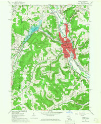
1965 Map of Hornell
USGS Topo · Published 1967About this map
The Canisteo River valley serves as the industrial and residential heart of this mid-1960s survey, dominated by the city of Hornell. This era shows a community deeply integrated with the Erie Lackawanna rail lines, which bifurcate the urban center and follow the river's path. To the west, the massive Almond Reservoir creates a significant water feature behind a dam on Canacadea Creek, surrounded by the protected grounds of a State Reforestation Area. This landscape transition from the densely developed city streets to the high, wooded ridges of Meeks Hill and Bald Hill illustrates the classic Southern Tier topography where steep hills constrain development to the narrow valley floors. Rural outposts like Bishopville and Hartsville Center offer a view into the agricultural and residential fringes of the county at a time when local schools like the Columbian Sch and North Hornell Sch anchored their respective neighborhoods.
Find a feature on this map
51 named features on this map. Tap any name to fly to it.
Don’t see what you’re looking for? This feature index may not catch every label — zoom into the map to look around manually.
Map Details
Editions of this 1965 Hornell Map
2 editions found
Other maps of this area

1915 · Hornell
USGS Topo · 1:62,500

1916 · Canaseraga
USGS Topo · 1:62,500

1918 · Hornell
USGS Topo · 1:62,500

1926 · Wellsville
USGS Topo · 1:62,500

1926 · Greenwood
USGS Topo · 1:62,500

1940 · Canaseraga
USGS Topo · 1:62,500

1950 · Elmira
USGS Topo · 1:250,000

1954 · South Canisteo
USGS Topo · 1:24,000
1954 · Canisteo
USGS Topo · 1:24,000

1958 · Elmira
USGS Topo · 1:250,000