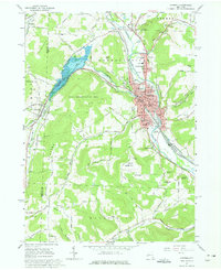
1965 Map of Hornell
USGS Topo · Published 1977About this map
The Canisteo River valley serves as the industrial and transport corridor for this region in the mid-1960s, anchored by the city of Hornell. The Erie-Lackawanna railroad runs centrally through the valley, passing through North Hornell and past the Hornell Airport. To the west, the landscape is defined by the Almond Lake reservoir, a major flood control feature created by the damming of Canacadea Creek. The map documents a dense concentration of civic and religious institutions within the city, including several schools like the Columbian Sch and the Hornell Sr High Sch, alongside numerous cemeteries such as Hope Cem and Rural Cem. In the surrounding highlands, smaller settlements like Hartsville Center and Bishopville are connected by a network of rural routes traversing peaks like Bald Hill and Meeks Hill.
Find a feature on this map
99 named features on this map. Tap any name to fly to it.
Don’t see what you’re looking for? This feature index may not catch every label — zoom into the map to look around manually.
Map Details
Editions of this 1965 Hornell Map
2 editions found
Other maps of this area

1915 · Hornell
USGS Topo · 1:62,500

1916 · Canaseraga
USGS Topo · 1:62,500

1918 · Hornell
USGS Topo · 1:62,500

1926 · Wellsville
USGS Topo · 1:62,500

1926 · Greenwood
USGS Topo · 1:62,500

1940 · Canaseraga
USGS Topo · 1:62,500

1950 · Elmira
USGS Topo · 1:250,000

1954 · South Canisteo
USGS Topo · 1:24,000
1954 · Canisteo
USGS Topo · 1:24,000

1958 · Elmira
USGS Topo · 1:250,000