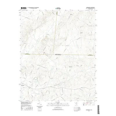
2017 Map of Hornsboro
USGS Topo · Published 2017About this map
The borderlands of Chesterfield County, South Carolina, and Union and Anson Counties in North Carolina converge in this 2017 survey, centered on the community of Hornsboro. The landscape is defined by the headwaters of the Pee Dee River basin, where numerous streams like Thompson Cr and Savannah Br carve through the terrain. Evidence of local industry and water management appears at the Rock Quarry Pond and Hutsey Millpond, while the southwestern corner shows the outskirts of Pageland.
Find a feature on this map
94 named features on this map. Tap any name to fly to it.
Don’t see what you’re looking for? This feature index may not catch every label — zoom into the map to look around manually.
Map Details
Editions of this 2017 Hornsboro Map
This is the sole edition of this map. No revisions or reprints were ever made.
Other maps of this area

1941 · Spartanburg
USGS Topo · 1:250,000

1953 · Spartanburg
USGS Topo · 1:250,000

1960 · Spartanburg
USGS Topo · 1:250,000

1963 · Spartanburg
USGS Topo · 1:250,000

1964 · Spartanburg
USGS Topo · 1:250,000

1968 · Ruby
USGS Topo · 1:24,000

1968 · Jefferson
USGS Topo · 1:24,000

1968 · Jefferson NE
USGS Topo · 1:24,000

1970 · Marshville
USGS Topo · 1:24,000
1970 · Wingate
USGS Topo · 1:24,000