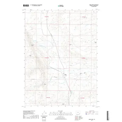
2017 Map of Horse Creek
USGS Topo · Published 2017About this map
Horse Creek sits at a strategic junction of high-plains topography and an extensive system of man-made irrigation, as seen in this 2017 survey of Laramie County. The landscape is defined by the Horse Creek Hogback and the steep walls of Fisher Canyon and Baker Canyon, while the local economy is etched into the earth through a complex network of water rights. This includes the McLaughlin-Ditch Number 6, Sophia Ditch, Elizabeth Ditch, and the S Horse Cr Ditch, all designed to manage the flow from the N Fork Horse Cr and its tributaries. Landmarks such as Chimney Rock and Eagle Hill rise above the drainage basins, serving as traditional navigational points. The map also records the presence of the McLaughlin Reservoir Number 2, illustrating the long-term human effort to store and divert water across this arid Wyoming terrain.
Find a feature on this map
37 named features on this map. Tap any name to fly to it.
Don’t see what you’re looking for? This feature index may not catch every label — zoom into the map to look around manually.
Map Details
Editions of this 2017 Horse Creek Map
This is the sole edition of this map. No revisions or reprints were ever made.
Other maps of this area

1905 · Sherman
USGS Topo · 1:125,000

1948 · Ragged Top Mountain
USGS Topo · 1:62,500

1950 · Ragged Top Mountain
USGS Topo · 1:62,500

1954 · Cheyenne
USGS Topo · 1:250,000

1955 · Goat Mountain
USGS Topo · 1:24,000

1958 · Cheyenne
USGS Topo · 1:250,000

1962 · Horse Creek
USGS Topo · 1:24,000

1962 · Federal
USGS Topo · 1:24,000

1962 · Dereemer Ranch
USGS Topo · 1:24,000

1962 · Farthing
USGS Topo · 1:24,000