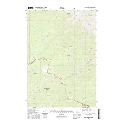
2017 Map of Horse Creek Pass
USGS Topo · Published 2017About this map
Horse Creek Pass marks a high-altitude crossing on the rugged border between Ravalli County, Montana, and Lemhi County, Idaho. This 2017 survey details the topographical meeting point of the Bitterroot National Forest and Salmon National Forest, characterized by high peaks such as Razorback Mtn and Cathedral Rock. Historically significant for its remote passage, the area includes the Horse Cr Hot Springs situated along the southern drainage. The map traces established routes like the Horse Creek Pass Rd and the Deer Creek Trail, which navigate the headwaters of numerous creeks including Chicken Cr and the various forks of Woods Cr. The terrain is defined by its deep drainages and sharp ridges, providing a clear view of the wilderness connectivity between these two national forests.
Find a feature on this map
41 named features on this map. Tap any name to fly to it.
Don’t see what you’re looking for? This feature index may not catch every label — zoom into the map to look around manually.
Map Details
Editions of this 2017 Horse Creek Pass Map
This is the sole edition of this map. No revisions or reprints were ever made.
Other maps of this area

1956 · Elk City
USGS Topo · 1:250,000

1960 · Elk City
USGS Topo · 1:250,000

1960 · Painted Rocks Lake
USGS Topo · 1:62,500

1960 · Shoup
USGS Topo · 1:62,500

1962 · Blue Joint
USGS Topo · 1:24,000

1962 · Horse Creek Butte
USGS Topo · 1:24,000

1962 · Nez Perce Peak
USGS Topo · 1:24,000

1982 · Bighorn Crags
USGS Topo · 1:100,000

1991 · Horse Creek Pass
USGS Topo · 1:24,000
1991 · Tincup Hill
USGS Topo · 1:24,000