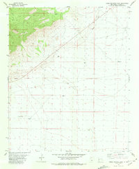
1981 Map of Horse Mountain East
USGS Topo · Published 1981About this map
Horse Mountain dominates the northwestern quadrant of this high-desert survey, where the terrain drops away into a series of strategic water points and drainage features. The landscape is defined by its reliance on groundwater, indicated by the numerous named wells scattered across the plains and foothills. These locations, such as McMaster Well, Alamo Well, and Stockyards Well, highlight the infrastructure necessary for ranching and livestock management in the arid Catron County environment.
Find a feature on this map
14 named features on this map. Tap any name to fly to it.
Don’t see what you’re looking for? This feature index may not catch every label — zoom into the map to look around manually.
Map Details
Editions of this 1981 Horse Mountain East Map
This is the sole edition of this map. No revisions or reprints were ever made.
Other maps of this area

1918 · Pelona
USGS Topo · 1:125,000

1954 · Tularosa
USGS Topo · 1:250,000

1954 · Clifton
USGS Topo · 1:250,000

1954 · Saint Johns
USGS Topo · 1:250,000

1954 · Socorro
USGS Topo · 1:250,000

1957 · Clifton
USGS Topo · 1:250,000

1957 · Saint Johns
USGS Topo · 1:250,000

1958 · Socorro
USGS Topo · 1:250,000

1958 · Clifton
USGS Topo · 1:250,000

1958 · Tularosa
USGS Topo · 1:250,000