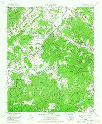
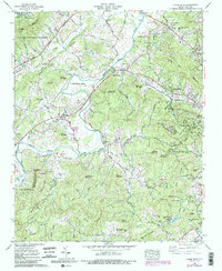
1965 Map of Horse Shoe
USGS Topo · Published 1967About this map
The French Broad River carves a dramatic path through this Henderson County landscape, most notably forming the distinct Horse Shoe Bend which gives the area its name. During the mid-1960s, the region was characterized by a blend of mountain agriculture, educational institutions like West Henderson High School, and several established youth retreats including Camp Osceola and the various branches of Camp Kanuga. The Southern Railway follows the river valley, connecting the community of Etowah to points east and west. Higher elevations are marked by landmarks such as Jumpoff Mountain and Jumpoff Rock, while the southern reaches contain numerous water bodies like Wolf Lake and Kanuga Lake. This era shows a transition from rural homesteads, evidenced by scattered family cemeteries like Fletcher Cem and Sentell Cem, toward early residential developments like Woodland Hills and Camelot.
Find a feature on this map
100 named features on this map. Tap any name to fly to it.
Don’t see what you’re looking for? This feature index may not catch every label — zoom into the map to look around manually.
Map Details
Editions of this 1965 Horse Shoe Map
5 editions found
Other maps of this area

1905 · Pisgah
USGS Topo · 1:125,000

1906 · Pisgah
USGS Topo · 1:125,000

1907 · Saluda
USGS Topo · 1:125,000

1935 · Brevard
USGS Topo · 1:24,000

1935 · Standingstone Mtn.
USGS Topo · 1:24,000

1935 · Horse Shoe
USGS Topo · 1:24,000

1935 · Hendersonville
USGS Topo · 1:24,000

1935 · Zirconia
USGS Topo · 1:24,000

1935 · Pisgah Forest
USGS Topo · 1:24,000

1936 · Skyland
USGS Topo · 1:24,000