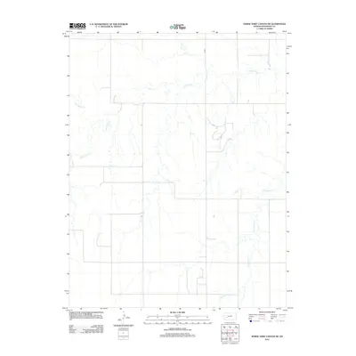
2012 Map of Horse Thief Canyon NE
USGS Topo · Published 2012About this map
The Pawnee River meanders across this rural section of Hodgeman County, Kansas, defining the hydrologic character of a landscape shaped by intermittent watercourses. In this sparsely populated prairie environment, drainage systems like Plum Cr, Hackberry Cr, and Cottonwood Cr create a dendritic pattern across the terrain. Human presence is marked primarily by the rigid grid of the public land survey system, evidenced by the straight path of 110 Rd and several unnamed section-line roads. The reliance on these natural water sources for agriculture and ranching is evident in how the limited infrastructure avoids the floodplains of the river. This survey captures the quiet, expansive nature of Western Kansas, where the natural topography of the river basins remains the most prominent feature of the geography.
Find a feature on this map
5 named features on this map. Tap any name to fly to it.
Don’t see what you’re looking for? This feature index may not catch every label — zoom into the map to look around manually.
Map Details
Editions of this 2012 Horse Thief Canyon NE Map
This is the sole edition of this map. No revisions or reprints were ever made.
Other maps of this area

1892 · Ness
USGS Topo · 1:125,000

1894 · Ness
USGS Topo · 1:125,000

1955 · Great Bend
USGS Topo · 1:250,000

1955 · Scott City
USGS Topo · 1:250,000

1957 · Great Bend
USGS Topo · 1:250,000

1958 · Great Bend
USGS Topo · 1:250,000

1958 · Scott City
USGS Topo · 1:250,000

1969 · Jetmore
USGS Topo · 1:24,000
1970 · Jetmore NW
USGS Topo · 1:24,000
1970 · Horse Thief Canyon
USGS Topo · 1:24,000