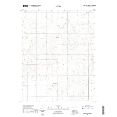
2018 Map of Horse Thief Canyon NE
USGS Topo · Published 2018About this map
The Pawnee River meanders across the northern half of this central Kansas landscape, carving a low valley through the agricultural plains of Hodgeman County. This 2018 survey shows a rural infrastructure defined by a rigid section-line grid, where roads like X Rd and S Rd facilitate movement across the open prairie. Seasonal drainage is provided by smaller watercourses such as Plum Cr in the north and Cottonwood Cr in the southeast, which cut modest breaks into the terrain. The map captures the enduring Public Land Survey System layout, with township boundaries like t21s r25w clearly dividing the vast acreage. This is a landscape of scale and efficiency, where the placement of thoroughfares like NW 212 Rd and Q Rd reflects a century of land management and rural connectivity.
Find a feature on this map
24 named features on this map. Tap any name to fly to it.
Don’t see what you’re looking for? This feature index may not catch every label — zoom into the map to look around manually.
Map Details
Editions of this 2018 Horse Thief Canyon NE Map
This is the sole edition of this map. No revisions or reprints were ever made.
Other maps of this area

1892 · Ness
USGS Topo · 1:125,000

1894 · Ness
USGS Topo · 1:125,000

1955 · Great Bend
USGS Topo · 1:250,000

1955 · Scott City
USGS Topo · 1:250,000

1957 · Great Bend
USGS Topo · 1:250,000

1958 · Great Bend
USGS Topo · 1:250,000

1958 · Scott City
USGS Topo · 1:250,000

1969 · Jetmore
USGS Topo · 1:24,000
1970 · Jetmore NW
USGS Topo · 1:24,000
1970 · Horse Thief Canyon
USGS Topo · 1:24,000