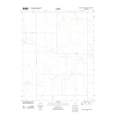
2012 Map of Horse Thief Canyon NW
USGS Topo · Published 2012About this map
Pawnee River meanders across this rural section of Finney County, forming the primary drainage for a landscape defined by seasonal watercourses and straight-line county roads. The northern reaches are carved by the tributaries of Hackberry Cr and Cottonwood Cr, while the southern area is marked by the winding path of Sand Cr. Human presence in this open plains environment is centered around the intersection of section-line routes such as Alamota Rd and N Hodgeman Co Line Rd. A significant point for local family history is Kitterville Cem, located near a sharp bend in the river. This 2012 survey illustrates the enduring agricultural grid of western Kansas, where water sources and remote cemeteries remain the primary landmarks in a vast prairie setting.
Find a feature on this map
9 named features on this map. Tap any name to fly to it.
Don’t see what you’re looking for? This feature index may not catch every label — zoom into the map to look around manually.
Map Details
Editions of this 2012 Horse Thief Canyon NW Map
This is the sole edition of this map. No revisions or reprints were ever made.
Other maps of this area

1955 · Scott City
USGS Topo · 1:250,000

1958 · Scott City
USGS Topo · 1:250,000
1970 · Horse Thief Canyon
USGS Topo · 1:24,000
1974 · Horse Thief Canyon SW
USGS Topo · 1:24,000
1974 · Kalvesta
USGS Topo · 1:24,000
1974 · Horse Thief Canyon NE
USGS Topo · 1:24,000
1974 · Beeler SE
USGS Topo · 1:24,000

1974 · Hay Canyon
USGS Topo · 1:24,000

1974 · Beeler SW
USGS Topo · 1:24,000

1974 · Dighton SE
USGS Topo · 1:24,000