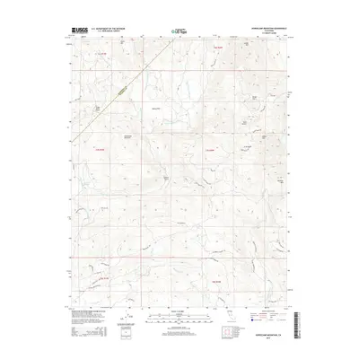
2015 Map of Horsecamp Mountain
USGS Topo · Published 2015About this map
Bailey Flats and Grub Gulch anchor this 2015 topographic study of the foothill transition between the Chowchilla River and Fresno River basins. The terrain is defined by prominent peaks including Horsecamp Mountain, Twin Sisters, and Buckeye Mtn, with a network of rural routes such as Old Wagon Rd and Ellerbrock Station Rd tracing the historical paths through Mariposa and Madera counties. Local-history researchers will find interest in the mapping of Specimen Springs and the Grupe Ranch Airport, along with the complex drainage of the W Fork, Middle Fork, and E Fork Chowchilla River. The landscape reveals a pattern of dispersed settlement and agricultural land use typical of the Sierra Nevada foothills, marked by ranch roads like Polk Ranch Rd and JWP Ranch Rd.
Find a feature on this map
56 named features on this map. Tap any name to fly to it.
Don’t see what you’re looking for? This feature index may not catch every label — zoom into the map to look around manually.
Map Details
Editions of this 2015 Horsecamp Mountain Map
This is the sole edition of this map. No revisions or reprints were ever made.
Other maps of this area

1912 · Mariposa
USGS Topo · 1:125,000

1942 · Raymond
USGS Topo · 1:62,500

1942 · Millerton Lake
USGS Topo · 1:62,500

1944 · Raymond
USGS Topo · 1:62,500

1945 · Millerton Lake
USGS Topo · 1:62,500

1947 · Mariposa
USGS Topo · 1:24,000

1947 · Mariposa
USGS Topo · 1:250,000

1947 · Mariposa
USGS Topo · 1:62,500
1947 · Stumpfield Mtn.
USGS Topo · 1:24,000
1947 · Ben Hur
USGS Topo · 1:24,000