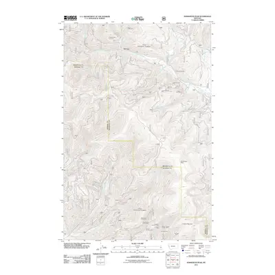
2011 Map of Horsehead Peak
USGS Topo · Published 2011About this map
Old Town sits at the heart of this drainage-rich landscape, where Ninemile Creek and its many tributaries carve through the Montana terrain. The area is defined by an extensive history of resource extraction, with a high concentration of mining operations scattered throughout the hills. Hard rock and placer claims like the Frances Copper Mine, the War Eagle Mine, and the Liquidator Mine speak to the region's industrial past.
Find a feature on this map
50 named features on this map. Tap any name to fly to it.
Don’t see what you’re looking for? This feature index may not catch every label — zoom into the map to look around manually.
Map Details
Editions of this 2011 Horsehead Peak Map
This is the sole edition of this map. No revisions or reprints were ever made.
Other maps of this area

1956 · Wallace
USGS Topo · 1:250,000

1959 · Tarkio
USGS Topo · 1:62,500

1959 · Perma
USGS Topo · 1:62,500

1959 · Plains
USGS Topo · 1:62,500

1960 · Wallace
USGS Topo · 1:250,000

1960 · Superior
USGS Topo · 1:62,500

1983 · Horsehead Peak
USGS Topo · 1:24,000
1983 · Tarkio
USGS Topo · 1:24,000
1983 · Stark South
USGS Topo · 1:24,000

1984 · Stark North
USGS Topo · 1:24,000