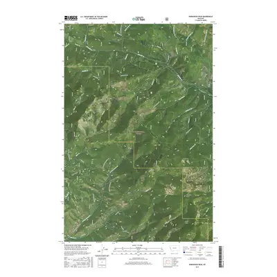
2017 Map of Horsehead Peak
USGS Topo · Published 2017About this map
Lolo National Forest dominates this mountain landscape along the border of Missoula and Mineral counties. This 2017 survey details a complex network of forest access roads and ridges, including the Ninemile Siegle Rd and King's Ridge Rd No 7889, which navigate the steep drainage basins of Ninemile Cr and its many tributaries. The area is defined by prominent topographical markers like Horsehead Peak and Lookout Mtn, connected by the high terrain of the Ninemile Divide. The mapping reflects a landscape utilized for forest management and recreation, where name-bearing gulches such as Malley Gulch and creeks like Saint Louis Cr serve as primary geographical anchors for modern land use and historical navigation.
Find a feature on this map
46 named features on this map. Tap any name to fly to it.
Don’t see what you’re looking for? This feature index may not catch every label — zoom into the map to look around manually.
Map Details
Editions of this 2017 Horsehead Peak Map
This is the sole edition of this map. No revisions or reprints were ever made.
Other maps of this area

1956 · Wallace
USGS Topo · 1:250,000

1959 · Tarkio
USGS Topo · 1:62,500

1959 · Perma
USGS Topo · 1:62,500

1959 · Plains
USGS Topo · 1:62,500

1960 · Wallace
USGS Topo · 1:250,000

1960 · Superior
USGS Topo · 1:62,500

1983 · Horsehead Peak
USGS Topo · 1:24,000
1983 · Tarkio
USGS Topo · 1:24,000
1983 · Stark South
USGS Topo · 1:24,000

1984 · Stark North
USGS Topo · 1:24,000