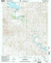
2004 Map of Horseshoe Dam
USGS Topo · Published 2006About this map
The Verde River corridor dominates this desert landscape, anchored by the infrastructure of Horseshoe Dam and the upper reaches of Bartlett Reservoir. This survey highlights the intersection of early 21st-century recreational facilities, such as the Ocotillo Boating Site and Echo Bay, with the remote ranching and wilderness heritage of the Tonto National Forest. The presence of the K A Ranch along the riverbanks and numerous named water sources like J-M Spring and Chalk Spring indicate the critical importance of riparian access in the arid Yavapai and Maricopa County borderlands.
Find a feature on this map
39 named features on this map. Tap any name to fly to it.
Don’t see what you’re looking for? This feature index may not catch every label — zoom into the map to look around manually.
Map Details
Editions of this 2004 Horseshoe Dam Map
This is the sole edition of this map. No revisions or reprints were ever made.
Other maps of this area

1887 · Verde
USGS Topo · 1:250,000

1892 · Verde
USGS Topo · 1:250,000

1929 · Turret Peak
USGS Topo · 1:125,000

1930 · Cave Creek
USGS Topo · 1:125,000

1933 · Turret Peak
USGS Topo · 1:125,000

1939 · Cave Creek
USGS Topo · 1:125,000

1954 · Holbrook
USGS Topo · 1:250,000

1954 · Mesa
USGS Topo · 1:250,000

1957 · Mesa
USGS Topo · 1:250,000

1957 · Holbrook
USGS Topo · 1:250,000