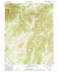
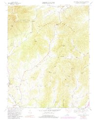
1967 Map of Horseshoe Mountain
USGS Topo · Published 1994About this map
Massies Mill serves as a focal point in this 1967 study of the Virginia Piedmont, situated where the Tye River winds past the Massies Mill Sch. The landscape is defined by the high ridges of Horseshoe Mountain and Bolton Mtn, which separate the agricultural valleys from the protected timberlands of the George Washington National Forest and Lesesne State Forest. Small rural settlements like Roseland, Jonesboro, and Bryant are connected by winding valley roads that trace the paths of Hat Creek and East Branch. Local genealogy and community life are anchored by landmarks such as Bethlehem Ch, Zion Hill Ch, and the Massie Memorial Ch. The map captures a moment of transition where traditional foothill settlements remain intact against a backdrop of prominent peaks like Mars Knob and High Top Mtn.
Find a feature on this map
44 named features on this map. Tap any name to fly to it.
Don’t see what you’re looking for? This feature index may not catch every label — zoom into the map to look around manually.
Map Details
Editions of this 1967 Horseshoe Mountain Map
5 editions found
Other maps of this area

1892 · Buckingham
USGS Topo · 1:125,000

1894 · Lexington
USGS Topo · 1:125,000

1935 · Amherst
USGS Topo · 1:48,000

1936 · Vesuvius
USGS Topo · 1:48,000

1939 · Amherst
USGS Topo · 1:62,500

1941 · Vesuvius
USGS Topo · 1:62,500

1943 · Lovingston
USGS Topo · 1:62,500

1946 · Lovingston
USGS Topo · 1:62,500

1947 · Roanoke
USGS Topo · 1:250,000

1950 · Amherst
USGS Topo · 1:62,500