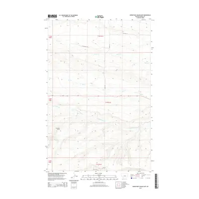
2014 Map of Horsethief Coulee East
USGS Topo · Published 2014About this map
N Fork McDonald Cr and Alkali Cr wind through the open ranching country of Fergus County in this modern survey. The drainage of Horsethief Coulee defines the southwestern landscape, while several named watercourses like Chippewa Cr and Fords Cr cut through the high plains. The transport network reflects a mix of regional connectivity and local ranch access, anchored by the east-west corridor of Us-87. Local history and family ties are evident in the naming of secondary roads and private paths, including McCartney Rd, Burnett Rd, and the Descheemaeker Drwy. Along the southern boundary, Forest Grove Rd serves the rural homesteads scattered across this central Montana terrain.
Find a feature on this map
17 named features on this map. Tap any name to fly to it.
Don’t see what you’re looking for? This feature index may not catch every label — zoom into the map to look around manually.
Map Details
Editions of this 2014 Horsethief Coulee East Map
This is the sole edition of this map. No revisions or reprints were ever made.
Other maps of this area

1889 · Big Snowy Mountain
USGS Topo · 1:250,000

1893 · Big Snowy Mountain
USGS Topo · 1:250,000

1941 · Judith Peak
USGS Topo · 1:62,500

1944 · Judith Peak
USGS Topo · 1:62,500

1954 · Roundup
USGS Topo · 1:250,000

1954 · Lewistown
USGS Topo · 1:250,000

1958 · Roundup
USGS Topo · 1:250,000

1959 · Lewistown
USGS Topo · 1:250,000

1970 · Forestgrove
USGS Topo · 1:24,000
1970 · Loco Ridge
USGS Topo · 1:24,000