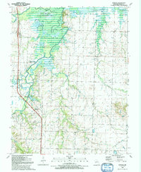
1991 Map of Horton
USGS Topo · Published 1991About this map
The Marmaton River and Little Osage River converge in this northern Vernon County landscape, creating a complex network of wetlands and oxbow lakes preserved within the Four Rivers State Wildlife Area. Named water bodies such as Horseshoe Lake, Spike Lake, and Hubler Lake define the bottomlands, while the terrain rises significantly at Blue Mound and Walker Mound to the east.
Find a feature on this map
34 named features on this map. Tap any name to fly to it.
Don’t see what you’re looking for? This feature index may not catch every label — zoom into the map to look around manually.
Map Details
Editions of this 1991 Horton Map
This is the sole edition of this map. No revisions or reprints were ever made.
Other maps of this area

1886 · Nevada
USGS Topo · 1:125,000

1887 · Butler
USGS Topo · 1:125,000

1894 · Butler
USGS Topo · 1:125,000

1894 · Nevada
USGS Topo · 1:125,000

1933 · Camp Clark
USGS Topo · 1:24,000

1934 · Papinsville
USGS Topo · 1:24,000

1936 · Rich Hill
USGS Topo · 1:24,000

1938 · Metz
USGS Topo · 1:24,000

1938 · Horton
USGS Topo · 1:24,000

1939 · Metz
USGS Topo · 1:24,000