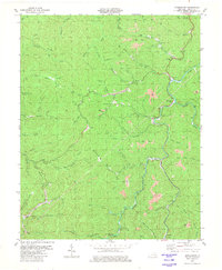
1980 Map of Hoskinston
USGS Topo · Published 1980About this map
The Middle Fork Kentucky River serves as the central artery for this mountainous region of Leslie County, where the coal industry profoundly reshaped the landscape by the early 1980s. Numerous Strip Mines and several oil wells are scattered across the high ridges, particularly near Muncy Creek and Little Stinnett Creek. Small communities like Hoskinston and Asher cling to the riverbank, while inland settlements such as Essie are found along the narrow hollows of Bowen Creek and Woodson Fork. Local genealogy is well-preserved through numerous scattered mountain cemeteries and country churches, including Grassy Branch Ch and Beech Fork Ch. The terrain is characterized by steep slopes and strategic passages like Stinnett Gap, reflecting an era of transition as traditional Appalachian life intersected with large-scale resource extraction.
Find a feature on this map
85 named features on this map. Tap any name to fly to it.
Don’t see what you’re looking for? This feature index may not catch every label — zoom into the map to look around manually.
Map Details
Editions of this 1980 Hoskinston Map
This is the sole edition of this map. No revisions or reprints were ever made.
Other maps of this area

1886 · Cumberland Gap
USGS Topo · 1:125,000

1887 · Jonesville
USGS Topo · 1:125,000

1888 · Cumberland Gap
USGS Topo · 1:125,000

1891 · Manchester
USGS Topo · 1:125,000

1891 · Cumberland Gap
USGS Topo · 1:125,000

1891 · Hazard
USGS Topo · 1:125,000

1891 · Jonesville
USGS Topo · 1:125,000

1903 · Harlan
USGS Topo · 1:48,000

1903 · Pineville
USGS Topo · 1:48,000

1916 · Harlan
USGS Topo · 1:48,000