
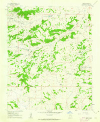
1961 Map of Hospah
USGS Topo · Published 1963About this map
The Hospah Oil Field defines the industrial footprint of this McKinley County landscape, centered around the settlement of Hospah and its adjacent landing strip. This early 1960s environment is a study in high-desert resource management, where water infrastructure like the Jake Chee Windmill, Steel Windmill, and Bull Camp Windmill provide essential support for ranching operations. The topography is marked by significant landmarks such as Pretty Rock, Gumbo Point, and the Mesita Americano, which rise above the complex network of dry washes including Sandoval Arroyo and Alfredo Padilla Arroyo. While the oil field and its related wells dominate the northern section, the southern reaches transition into a terrain of tanks and passes, including Bobcat Pass and the Floyd Lee Tank. To the east, the small settlement of Lucero sits near the arroyos, illustrating the scattered nature of human habitation in this arid region.
Find a feature on this map
26 named features on this map. Tap any name to fly to it.
Don’t see what you’re looking for? This feature index may not catch every label — zoom into the map to look around manually.
Map Details
Editions of this 1961 Hospah Map
2 editions found
Other maps of this area

1883 · Mt. Taylor
USGS Topo · 1:250,000

1886 · Mt. Taylor
USGS Topo · 1:250,000

1892 · Mt. Taylor
USGS Topo · 1:250,000

1899 · Mt. Taylor
USGS Topo · 1:250,000

1958 · Albuquerque
USGS Topo · 1:250,000

1961 · El Dado
USGS Topo · 1:24,000

1961 · Piedra De La Aguila
USGS Topo · 1:24,000

1961 · Whitehorse Rincon
USGS Topo · 1:24,000

1961 · Whitehorse
USGS Topo · 1:24,000
1961 · Mesita Americana
USGS Topo · 1:24,000