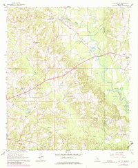
1965 Map of Hot Coffee
USGS Topo · Published 1982About this map
Hot Coffee and the surrounding piney woods of Covington County and Jones County appear here during a period of transition in the mid-1960s. The landscape is defined by the winding Leaf River and its major tributary, Oakohay Creek, which drain a region characterized by small rural settlements and scattered family landmarks. The map documents numerous community pillars, from Hopewell Sch to rural sanctuaries like Union Ch and Bethel Ch.
Find a feature on this map
37 named features on this map. Tap any name to fly to it.
Don’t see what you’re looking for? This feature index may not catch every label — zoom into the map to look around manually.
Map Details
Editions of this 1965 Hot Coffee Map
2 editions found
Other maps of this area

1953 · Hattiesburg
USGS Topo · 1:250,000

1958 · Hattiesburg
USGS Topo · 1:250,000

1964 · Seminary
USGS Topo · 1:24,000

1965 · Hebron
USGS Topo · 1:24,000

1965 · Hot Coffee
USGS Topo · 1:24,000

1965 · Moselle
USGS Topo · 1:24,000

1974 · Williamsburg
USGS Topo · 1:24,000

1974 · Soso
USGS Topo · 1:24,000

1974 · Collins
USGS Topo · 1:24,000

1975 · Taylorsville
USGS Topo · 1:24,000