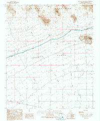
1990 Map of Hot Rock Mountain
USGS Topo · Published 1990About this map
The Belmont Mountains dominate the northern landscape of this Maricopa County study, giving way to the arid expanse of the Tonopah Desert to the south. This 1990 provisional survey records a stark desert environment where human infrastructure is largely centered around water management and transit. The Granite Reef Aqueduct cuts a distinct line across the terrain, flanked by a Road on Levee, illustrating the massive engineering efforts required to move water through the region.
Find a feature on this map
16 named features on this map. Tap any name to fly to it.
Don’t see what you’re looking for? This feature index may not catch every label — zoom into the map to look around manually.
Map Details
Editions of this 1990 Hot Rock Mountain Map
This is the sole edition of this map. No revisions or reprints were ever made.
Other maps of this area

1942 · Vicksburg
USGS Topo · 1:250,000

1954 · Phoenix
USGS Topo · 1:250,000

1957 · Phoenix
USGS Topo · 1:250,000

1958 · Phoenix
USGS Topo · 1:250,000

1960 · Phoenix
USGS Topo · 1:250,000

1961 · Big Horn Mts
USGS Topo · 1:62,500

1962 · Belmont Mts
USGS Topo · 1:62,500

1962 · Cortez Peak
USGS Topo · 1:62,500

1962 · Arlington
USGS Topo · 1:62,500

1969 · Phoenix
USGS Topo · 1:250,000