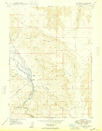
1949 Map of Hot Spring
USGS Topo · Published 1949About this map
The Bruneau River carves a deep path through Owyhee County, defining a landscape shaped by subterranean geothermal activity and early hydraulic engineering. Geologic features like the Indian Bathtub and numerous Artesian Wells point to the significant water resources that sustained this arid region. The infrastructure of the late 1940s is clearly visible, showing how water was managed via the Bruneau River Canal and the Buckaroo Ditch to support local ranching and the settlement at Hot Spring. Evidence of human adaptation to the river's flow is found at Buckaroo Dam and Harris Dam, while natural landmarks like Roberson Cave and the dramatic Bruneau Canyon highlight the varied topography. This survey captures a moment when the small-scale irrigation network and natural thermal springs were the primary drivers of life along the canyon floor.
Find a feature on this map
27 named features on this map. Tap any name to fly to it.
Don’t see what you’re looking for? This feature index may not catch every label — zoom into the map to look around manually.
Map Details
Editions of this 1949 Hot Spring Map
This is the sole edition of this map. No revisions or reprints were ever made.
Other maps of this area

1947 · Bruneau
USGS Topo · 1:62,500

1947 · Indian Cove
USGS Topo · 1:24,000

1947 · Sand Dunes
USGS Topo · 1:24,000

1947 · Bruneau
USGS Topo · 1:24,000

1947 · Sugar Valley
USGS Topo · 1:24,000

1947 · Hot Spring
USGS Topo · 1:24,000

1948 · Sand Dunes
USGS Topo · 1:24,000

1948 · Indian Cove
USGS Topo · 1:24,000

1948 · Sugar Valley
USGS Topo · 1:24,000
1948 · Bruneau
USGS Topo · 1:24,000