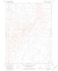
1967 Map of Hot Springs Creek
USGS Topo · Published 1983About this map
Mala Vista Ranch sits at the eastern edge of this High Desert landscape, where the seasonal flow of Hot Springs Creek winds toward its confluence with the Marys River. This 1960s survey documents a region defined by remote ranching operations and essential water management, evidenced by the Gaging Sta and Water Tank that support local livestock and irrigation. The terrain is crisscrossed by a network of primitive routes, including a prominent Jeep Trail that climbs through the draws and ridges between Hanks Fk and the southern creek beds. The presence of a Landing Area near the ranch suggests the importance of light aircraft for traversing these expansive distances in northeastern Elko County. Numerous unnamed Spring and Springs labels indicate the vital, scattered water sources that dictated the placement of human activity in this arid basin.
Find a feature on this map
10 named features on this map. Tap any name to fly to it.
Don’t see what you’re looking for? This feature index may not catch every label — zoom into the map to look around manually.
Map Details
Editions of this 1967 Hot Springs Creek Map
2 editions found
Other maps of this area

1955 · Wells
USGS Topo · 1:250,000

1958 · Wells
USGS Topo · 1:250,000

1961 · Wells
USGS Topo · 1:250,000

1967 · Hanks Creek SW
USGS Topo · 1:24,000

1967 · Black Butte SW
USGS Topo · 1:24,000

1967 · Hot Springs Creek
USGS Topo · 1:24,000

1967 · Twin Buttes
USGS Topo · 1:24,000

1967 · Stag Mountain
USGS Topo · 1:24,000

1967 · Buena Vista Ranch
USGS Topo · 1:24,000

1967 · Peko Peak
USGS Topo · 1:24,000