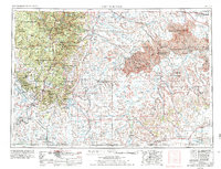
1955 Map of Hot Springs
USGS Topo · Published 1978About this map
The Black Hills dominate the western portion of this mid-century survey, rising sharply from the surrounding plains to heights at Harney Peak and the famous Mount Rushmore monument. This landscape transitions from the protected pines of Custer State Park and Wind Cave National Park into the intricate, eroded terrain of the Badlands National Monument to the east. The map records a critical era for the Pine Ridge Indian Reservation, documenting the distribution of communities like Wounded Knee, Manderson, and Porcupine. Water management is prominent through the Angostura Reservoir on the Cheyenne River, while the industrial and military footprint of the era is evidenced by the railroad-linked towns of Edgemont and the ammunition storage site at Igloo.
Find a feature on this map
134 named features on this map. Tap any name to fly to it.
Don’t see what you’re looking for? This feature index may not catch every label — zoom into the map to look around manually.
Map Details
Editions of this 1955 Hot Springs Map
5 editions found

Other maps of this area

1893 · Rapid
USGS Topo · 1:125,000

1894 · Deadwood
USGS Topo · 1:125,000

1894 · Hermosa
USGS Topo · 1:125,000

1896 · Oelrichs
USGS Topo · 1:125,000

1896 · Harney Peak
USGS Topo · 1:125,000

1898 · Sundance
USGS Topo · 1:125,000

1898 · Rapid
USGS Topo · 1:125,000

1899 · Newcastle
USGS Topo · 1:125,000

1900 · Oelrichs
USGS Topo · 1:125,000

1901 · Hermosa
USGS Topo · 1:125,000