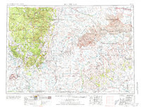
1955 Map of Hot Springs
USGS Topo · Published 1977About this map
Hot Springs serves as the gateway to this varied South Dakota landscape, where the southern reaches of the Black Hills meet the open plains. In the mid-1950s, the region was defined by a mix of early tourism and military operations, anchored by the Black Hills Ordnance Depot near Provo and the expansive Pine Ridge Indian Reservation to the east. The terrain transitions from the high peaks of Mount Rushmore and Harney Peak down to the arid, broken lands of the Badlands National Monument.
Find a feature on this map
112 named features on this map. Tap any name to fly to it.
Don’t see what you’re looking for? This feature index may not catch every label — zoom into the map to look around manually.
Map Details
Editions of this 1955 Hot Springs Map
5 editions found

Other maps of this area

1893 · Rapid
USGS Topo · 1:125,000

1894 · Deadwood
USGS Topo · 1:125,000

1894 · Hermosa
USGS Topo · 1:125,000

1896 · Oelrichs
USGS Topo · 1:125,000

1896 · Harney Peak
USGS Topo · 1:125,000

1898 · Sundance
USGS Topo · 1:125,000

1898 · Rapid
USGS Topo · 1:125,000

1899 · Newcastle
USGS Topo · 1:125,000

1900 · Oelrichs
USGS Topo · 1:125,000

1901 · Hermosa
USGS Topo · 1:125,000