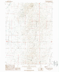
1988 Map of Hot Springs Peak
USGS Topo · Published 1989About this map
Hot Springs Peak anchors this corner of the Hot Springs Range in the late 1980s, overseeing a landscape defined by Nevada's mining heritage. This provisional study captures a high-desert environment where resource extraction and water access dictated the patterns of human activity. The western slopes are riddled with numerous mining operations, including the Prentiss Mine, Wholey Mine, and Cahill Mine, along with several clusters of Mine Shafts. These workings emphasize the intense mineral exploration of the region, situated between the expansive Paradise Valley and the smaller Eden Valley to the southeast.
Find a feature on this map
20 named features on this map. Tap any name to fly to it.
Don’t see what you’re looking for? This feature index may not catch every label — zoom into the map to look around manually.
Map Details
Editions of this 1988 Hot Springs Peak Map
This is the sole edition of this map. No revisions or reprints were ever made.
Other maps of this area

1882 · Paradise
USGS Topo · 1:250,000

1893 · Paradise
USGS Topo · 1:250,000

1945 · Osgood Mountains
USGS Topo · 1:62,500

1945 · Hot Springs
USGS Topo · 1:62,500

1947 · Osgood Mountains
USGS Topo · 1:62,500

1947 · Hot Springs Peak
USGS Topo · 1:62,500

1955 · McDermitt
USGS Topo · 1:250,000

1958 · Paradise Valley
USGS Topo · 1:62,500

1959 · McDermitt
USGS Topo · 1:250,000

1959 · Bliss
USGS Topo · 1:62,500