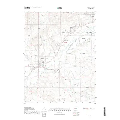
2019 Map of Hotchkiss
USGS Topo · Published 2019About this map
The North Fork Gunnison River carves a central path through this Delta County landscape, where the town of Hotchkiss serves as a hub for the surrounding plateau country. The terrain is defined by a series of prominent elevations, including Powell Mesa, Rogers Mesa, and Sunshine Mesa, which reflect the region's characteristic flat-topped geography. An intricate network of irrigation systems, such as the Fire Mountain Canal, Farmers Ditch, and Short Ditch, indicates the intensive agricultural management required to sustain this high-altitude valley. Local landmarks include the Fair Grounds and Riverside Cem near the town center, while aviation activity is noted at North Fork Valley Airport and Boeing Field. Small settlements and named heights like Duke Hill and Knob Hill provide specific points of interest for local history and genealogy research.
Find a feature on this map
73 named features on this map. Tap any name to fly to it.
Don’t see what you’re looking for? This feature index may not catch every label — zoom into the map to look around manually.
Map Details
Editions of this 2019 Hotchkiss Map
This is the sole edition of this map. No revisions or reprints were ever made.
Other maps of this area

1955 · Black Ridge
USGS Topo · 1:24,000

1955 · Lazear
USGS Topo · 1:24,000

1956 · Montrose
USGS Topo · 1:250,000

1959 · Montrose
USGS Topo · 1:250,000

1960 · Montrose
USGS Topo · 1:250,000
1965 · Gray Reservoir
USGS Topo · 1:24,000
1965 · Dry Creek
USGS Topo · 1:24,000
1965 · Paonia
USGS Topo · 1:24,000
1965 · Crawford
USGS Topo · 1:24,000
1965 · Bowie
USGS Topo · 1:24,000