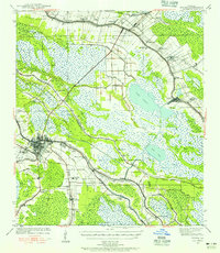
1939 Map of Houma
USGS Topo · Published 1956About this map
Bayou Lafourche and its branching distributaries define the settlement patterns of this low-lying coastal region in the late 1930s. The map illustrates the classic South Louisiana "long lot" land division, where narrow ribbons of high ground support communities like Raceland, Lockport, and Clotilda, while the surrounding landscape is dominated by expansive marshes and water bodies such as Lake Fields and Long Lake. The Southern Pacific railroad parallels the bayou, serving sugar-producing areas and industrial sites like the Aragon Plantation and Myrtle Grove.
Find a feature on this map
74 named features on this map. Tap any name to fly to it.
Don’t see what you’re looking for? This feature index may not catch every label — zoom into the map to look around manually.
Map Details
Editions of this 1939 Houma Map
This is the sole edition of this map. No revisions or reprints were ever made.
Other maps of this area

1891 · Hahnville
USGS Topo · 1:62,500

1892 · Lac Des Allemands
USGS Topo · 1:62,500

1892 · Gibson
USGS Topo · 1:62,500

1892 · Cut-Off
USGS Topo · 1:62,500

1892 · Houma
USGS Topo · 1:62,500

1892 · Thibodaux
USGS Topo · 1:62,500

1894 · Bayou De Large
USGS Topo · 1:62,500

1894 · Lake Felicity
USGS Topo · 1:62,500

1894 · Dulac
USGS Topo · 1:62,500

1897 · Gibson
USGS Topo · 1:62,500